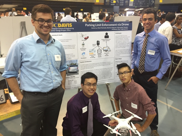
Final Remarks

Project Summary

We’ve created a two part system to allow DJI Phantom 3 drones to be used for parking enforcement. The first component, the ‘Patrol’ Android application allows the Phantom 3 send images (along with GPS, and timestamp) to our server, which is the 2nd component of this project. The server runs license plate recognition, data aggregation upon the results, applies enforcement logic, and finally runs a web interface for users to view and process citations. Our system has been made robust with authentication to ensure only approved drones can submit evidence to the system.

Users are able to access our user interface to view and process citations at: http://taglabrouter.genomecenter.ucdavis.edu/webservice/

Resources:

  1. All project code can be found at: https://github.com/quadsquad193/phantomboreas
  2. User manual can be found at: https://www.dropbox.com/s/syu4eotxcqmv218/QuadcopterUserManual.pdf?dl=0
  3. Patrol Android application apk could be found at: https://www.dropbox.com/s/oodbwicxhjcack4/app-debug.apk?dl=0
  4. Project Overview Video: https://www.youtube.com/watch?v=6PEZUbAusp0


Thanks again to Professor Tagkopoulos and Professor Liu for their guidance and support.

-Baotuan, Kelvin, Mark, and Alex

IMG_3647

Week 10 Android App Updates!

After the last 2 quarters worth of development, we have completed the Android app! The design hasn’t changed much since the Week 7 updates, but we cleaned it up, added the proper attributions to the source code, and packaged it all up into our Github project.

You can find the final codebase (nicknamed phantomboreas) on Github.

Week 7 Android App Updates!

The Android app is nearly done!

First, our app now authenticates with the server using a token system.

Moreover, we redesigned the app to follow Material Design standards. To that end, we added a tabbed display: one tab for the video stream / image upload functionality and another tab for a gallery. Moreover, the photo capture button’s design was made in line with the Material Design theme.

A gallery was added so parking officers can view their recent photo captures. Given the extremely high resolution images captured by the Phantom 3, we opted to use the Picasso library to load the images efficiently.

Here are screenshots of those tabs:


Lastly, we used Android Asset Studio (https://romannurik.github.io/AndroidAssetStudio/) to create app and web icons. Here is a preview:web_hi_res_512.png

Mobile: GPS/Timestamps & Next Up!

33

We successfully implemented GPS and Timestamp retrieval. We are now able to send this data with the pictures of the license plates to the server. The server now has the tools to implement business logic regarding actual time-based parking enforcement!

Next up for the mobile app is implementing authentication so unauthorized users cannot simply download the apk and send off clock.pngpictures. The mobile and server teams will be working largely in concert with one another for this.

Lastly, we are about 3 weeks from a preliminary delivery to our clients so stay tuned!

Spring Break Update: Autonomous Flight

dji-phantom-2-quadcopters-uk.png

I have been spending the spring break exploring DJI’s Android Waypoints API for autonomous control of the quadcopter. The API allows us to execute a custom mission by creating ‘MissionSteps’ and inserting them into a queue to be processed sequentially by the quadcopter. MissionSteps are simple actions such as taking off, landing,  gimbal manipulation, taking a picture, yaw of the quadcopter, and the Waypoints feature, which involves setting a GPS coordinate and altitude to which the quadcopter will automatically fly. We originally intended to map out a simple scenario in a parking lot for a demo of our system. The quadcopter would fly on its own to predetermined parking spots, take a picture, and send it off for processing on our server. However, we have run into much difficulty in developing with Waypoints. The API is poorly documented, with limited description of the behavior of the different MissionSteps. I had to try many of the mission steps just to discover the exact behavior. This has proven rather dangerous. In fact, early today, while testing, the quadcopter suddenly took off and crashed into my house. Fortunately, I was able to catch the drone as it fell. The only damage to the drone was a broken propeller. I have ordered replacements and they should arrive by this Sunday. After this experience, I question the safety and viability of pursuing an autonomous system. We shall discuss with Professor Tagkopoulos at our next meeting on how we should proceed on this portion of the project.

Android App: Half-way mark

We made it to the end of Winter Quarter with a successful demo to our professor.

We were able to successfully control the drone, take a picture onto the drone’s SD card, download that image onto the mobile phone’s storage, and upload it to a server via an HTTP Post.

Picture Taking

We utilized the DJI SDK API and expanded upon it to save an image onto a known location for further processing. We encountered many difficulties with establishing the connection, but it’s working now.

Picture Transfer

The Android App successfully runs a media scanner on the DJI Phantom 3’s SD card and transfers it to the Android App.

Picture Upload

The Android App successfully uploads the image to a server via an HTTP Post.

Server

Currently the server is an Ad-Hoc network setup from one of our computers. It reads the incoming image feed, processes it, and performs database analysis and storage. Post analysis of the image, the server stores the image itself, the captured license plate, the latitude/longitude, and the timestamp of the image.

Known Issues

  • The captured image isn’t indexed by the Android device, but we confirmed that it indeed gets stored onto the phone storage. We can upload the image from that known not-indexed location. Because of this indexing issue, you can’t see the image in the gallery, but you can see it with more robust file explorer apps.
  • We currently don’t query the DJI Phantom 3 for the longitude & latitude of the captured image’s location. We also currently don’t post the timestamp of the image. Currently those are hard-coded, but will later be fixed to reflect actual coordinates and timestamps.

Updates on Mobile App

We managed to get the Sample DJI Tutorial App working. The app streams the video from the drone, with buttons to capture images and record video.

From here, we plan to attach server communication code to send the images to a server for further processing.

Challenge: we expect to have to do a bit of research on how to load images from the Phantom 3 SD Card or if we can intercept the image in the “capture button” code.